Route
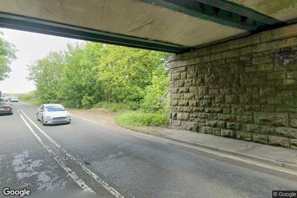
CHESTERFIELD ROAD A619
low bridges, 4.4 m clearance, low bridge, bridge clearance
Eastern
Last verified
27 Mar 2026
Information
Restriction
- Hazard category
- low bridges
- Road
- CHESTERFIELD ROAD A619
- Location
- CHESTERFIELD ROAD A619
- Clearance
- 4.4 m
- Clearance (imperial)
- 14' 6"
- Maximum width
- This will become available as we collect more information
- Maximum weight
- This will become available as we collect more information
- Problem type
- low bridge
- Restriction type
- bridge clearance
- Standard coach affected
- This will become available as we collect more information
- Single-decker affected
- UnknownCheck directly
- Double-decker affected
- UnknownCheck directly
- Buses and coaches affected
- This will become available as we collect more information
- Coaches affected
- This will become available as we collect more information
- Signposted
- YesConfirmed
Operational notes
- Description
- Signed height from the Network Rail bridge height workbook. Verify local bridge signage before coach travel.
- Alternative route
- This will become available as we collect more information
- Reported by
- Network Rail bridge height workbook
Source detail
- Network Rail reference
- PSE/74
- ELR
- PSE
- Bridge ID
- 74
- Span
- A
- Mileage
- 152.0579
- OS reference
- SK548778
- Bridge type
- Underline Bridge
- Network Rail region
- Eastern
- Network Rail route
- North and East
Images
 Google Street View
Nearby places
Closest places of other types within 5 mi.
Nearby route warnings
Mapped route warnings in this area. Always confirm local signage and coach access before travel.
Route1.3 mi
HAGONFIELD BRIDGE, STEETLEY LANE
low bridges, 3.8 m clearance, low bridge, bridge clearance
Route1.5 mi
CANAL BRIDGE
low bridges, 2.9 m clearance, low bridge, bridge clearance
Route2.6 mi
SHEFFIELD ROAD, A616
low bridges, 4.1 m clearance, low bridge, bridge clearance
Route3.0 mi
WOODS LANE
low bridges, 4.04 m clearance, low bridge, bridge clearance