Route
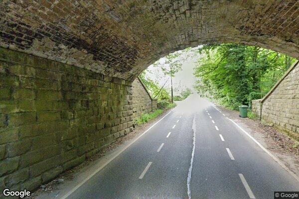
COPLEY LANE
low bridges, 4.3 m clearance, low bridge, bridge clearance
Eastern
Last verified
27 Mar 2026
Information
Restriction
- Hazard category
- low bridges
- Road
- COPLEY LANE
- Location
- COPLEY LANE
- Clearance
- 4.3 m
- Clearance (imperial)
- 14' 3"
- Maximum width
- This will become available as we collect more information
- Maximum weight
- This will become available as we collect more information
- Problem type
- low bridge
- Restriction type
- bridge clearance
- Standard coach affected
- This will become available as we collect more information
- Single-decker affected
- UnknownCheck directly
- Double-decker affected
- YesConfirmed
- Buses and coaches affected
- This will become available as we collect more information
- Coaches affected
- This will become available as we collect more information
- Signposted
- YesConfirmed
Operational notes
- Description
- Signed height from the Network Rail bridge height workbook. Verify local bridge signage before coach travel.
- Alternative route
- This will become available as we collect more information
- Reported by
- Network Rail bridge height workbook
Images
 Google Street View
Nearby places
No other place types were found within 5 mi yet. This will fill out as more datasets are imported.
Nearby route warnings
Mapped route warnings in this area. Always confirm local signage and coach access before travel.
Route2.4 mi
B6115 DENBY LANE,""PINFOLD BRIDGE""
low bridges, 3.7 m clearance, low bridge, bridge clearance
Route3.4 mi
STATION ROAD,BROCKHOLES
low bridges, 3.7 m clearance, low bridge, bridge clearance
Route4.6 mi
A628 BARNSLEY ROAD, HOYLAND SWAINE
low bridges, 4.1 m clearance, low bridge, bridge clearance
Route4.9 mi
DEADMANSTONE NO.1 ( WAIN PARK )
low bridges, 2.21 m clearance, low bridge, bridge clearance