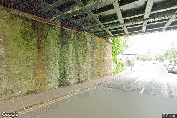
Route
Balaclava Road (St. Mary's Road) (HAM)
low bridges, 4.27 m clearance, low bridge, bridge clearance
Southern
Last verified
27 Mar 2026
Information
Restriction
- Hazard category
- low bridges
- Road
- Balaclava Road (St. Mary's Road) (HAM)
- Location
- Balaclava Road
- Clearance
- 4.27 m
- Clearance (imperial)
- 14' 0"
- Maximum width
- This will become available as we collect more information
- Maximum weight
- This will become available as we collect more information
- Problem type
- low bridge
- Restriction type
- bridge clearance
- Standard coach affected
- This will become available as we collect more information
- Single-decker affected
- UnknownCheck directly
- Double-decker affected
- YesConfirmed
- Buses and coaches affected
- This will become available as we collect more information
- Coaches affected
- This will become available as we collect more information
- Signposted
- YesConfirmed
Operational notes
- Description
- Signed height from the Network Rail bridge height workbook. Verify local bridge signage before coach travel.
- Alternative route
- This will become available as we collect more information
- Reported by
- Network Rail bridge height workbook
Images
 Google Street View
Nearby places
Closest places of other types within 5 mi.
Parking1.0 mi
Lamberts Road
1 bays, Free, max stay 20 minutes.
Attraction1.5 mi
Hampton Court Palace
historic site
Parking1.5 mi
High Street
1 bays, Free, max stay 30 minutes.
Parking1.5 mi
Hampton Court Station
£15.00 per day. Pay at station ticket office, credit cards accepted.
Hotel1.6 mi
Travelodge London Chessington Tolworth
Travelodge
Parking1.7 mi
Fairfield Road, Off Wheatfield Way
1 bays, Free, Max stay 1 hour.
Nearby route warnings
Mapped route warnings in this area. Always confirm local signage and coach access before travel.